
Llandovery Walk No. 2
This walk started after a Roman Camp caught my eye on the OS map below.
A walk along lanes and some more history, wondering what the locals and the Romans would have made of each other. Some locals may well have been of the Deise. It was also not lost on me I am about 1/4 Deise via my Arrigan’s and Holohan’s. So, I was wandering around the Kingdom of Dyfed or Demetia as it was before about the 8th century. The Deisi tribe from Co. Waterford were used by the Romans as protectors from other Irish pirates plundering the coastline of West Wales. Also close enough to Dolaucothi gold mines to make paying some lads and lasses from Waterford.

Eva and I walked up the incline of Heol Gwernfelen, expecting some yellow Alder (Gwern felen) somewhere around.

First bit of history I will note is of Troedrhiw felen, in the tithe map data base from the National Library of Wales there was a field on the right as we walked up which I identified (later) as part of land owned by Thomas William Rogers, the occupier of Troedrhiw felen farm was Ebenezer Thomas, near where I walked were ‘Cots and Gardens’ of less than half an acre and fields up to about 4 acres[1]. See below.

In the 1841 census the occupier was Ann Evans (age given 35 this was usually rounded down so she could have been up to 39) she was a farmer, also there was Daniel Evans aged 12 probably her son (these details weren’t specified on the 1841 census) and Ann Williams aged 4.[2]
Up the hill again and the place next I’ll mention is Pant Telych. Newspapers as I have mentioned before, are invaluable sources for family history if you can find any mentions.
As an example
“Trecastle Notes and News…
We regret to chronicle the sad death and burial of Mrs Elizabeth Jones, Cae’rathraw Farm, near Carnarvon, North Wales, and youngest daughter of Mr G. George and the late Mrs George, of Trawsllwyndu Farm, Cwmwysg, the deceased was a faithful member of Saron Congregational Chapel. Cwmwysg, before she married and left for Carnarvon, and was greatly respected. Her mortal remains were conveyed from Carnarvon to Cwmwysg burial ground. A large number of relatives and friends were present. Letters of sympathy were read by the pastor of Cwmwysg Chapel from Rev, and Mrs Stanley Jones, pastor of Salem Congregational Chapel, Carnarvon; also a letter from Salem Church members and congregation. The officiating minister was the Rev. J. C. Jones, pastor of Cwmwysg Congregational Chapel. The coffin bore the following inscription, Elizabeth Jones, died August 12nd, 1919, aged 42 years. The chief mourners were her husband Mr W. R. Jones, Cae’rathraw, and his brother from Carnarvon Messrs. W. and P. George, Trawsllwyndu, brothers Mr G. George, father, who is over 84 years of age was unable to be present Messrs. T. and W. George, Castelldu, uncles. Miss A. G. George, Castelldu Mr and Mrs Watkins, Brynmain Messrs. Tom and George George. Gellfau Mr and Mrs Jones, Pant Telych, Llandovery Mr and Mrs Davies, Heol-y-dwr, Cray Miss Jones, I Blaenau Mr and Mrs Morgan, Maesyreglwys, Glyntawe, cousins. As well as the following relatives, Messrs. George I and William Mathias, Cwmdwr Mr and Miss Henwen Jeffreys, Briton Ferry, Mr Tom Morgan, Maeseglwys, Miss Matthias, Abercrave Mr and Mrs Evans, Tirmawr, Trallong Mr and Mrs Evans, Stange. Llanddeusant Miss Thomas, Portis, etc. Refreshments were provided at the Vestry Room close by the Chapel for all those that attended the funeral from a distance.”[3]
You can put together a fairly detailed family tree for the George family of Cwmwysg, about 9 miles from Llandovery.

Dagfa, next on our route, possibly ‘tagfa’ a bottleneck, choke, jam, it’s near the Roman Road, local knowledge has it as a place where Roman soldiers were strangled, that might be true… or maybe not…
In 1824 The Cambrian reported.
“AUCTION, to be sold At the King’s-Head Inn, in LLANDOVERY, in the said county [[Carmarthenshire], on SATURDAY, the 20th day of MARCH next, between the hours of three and five of the clock in the afternoon, subject to conditions of sale to be then produced, or in the meantime by Private Contract, By RICHARD JONES, Auctioneer, ALL that FREEHOLD MESSUAGE, FARM, & LANDS, with the APPURTENANCES, called DAGFA, containing, by admeasurement, 110 Acres (and whereof 35 Acres, or thereabouts, is Woodland), and situate in the parish of Mothvey, in the said county [Carmarthenshire]. The dwelling house is lately erected at a considerable expense. and the other buildings are in good repair. The premises have a Right of Common attached to them, on the Mothvey Mountain and Black Mountain, and are capable of considerable improvements, and lie near the turnpike-road leading from Llandovery to Trecastle and within three miles of the former place, and six miles of the latter place. For further particulars apply to the Auctioneer, or at the Office of Mr. Edward Jones, in Llandovery.”[4]
About 25 years later years later it was the home of Elizabeth Jones a widow aged 41, Head of the household, born Llandingad, Carmarthenshire a Farmer of 112 Acres, her son Rees Jones unmarried aged 28, born Llandingad, Carmarthenshire an Agricultural Labourer, daughter Gwen Jones unmarried 24, born Llandingad, Carmarthenshire a General Servant, William Williams unmarried aged 45, born Llandingad, Carmarthenshire an Agricultural Labourer and David Williams unmarried 42, born Llandingad, Carmarthenshire an Agricultural Labourer.[5]
Way back into time and about 6km into our walk Eva and I arrived at the Roman camp, the field where the Roman camp was looks like this now.

I wonder if it was as quiet 1700 years ago.
Looking at the present-day OS map, some internet research and with thanks to CADW. It is described…
“The monument comprises a well-preserved Roman practice camp that primarily survives as an extant earthen bank with well-defined central entrances and associated tutuli, or entrance shielding ditches. The camp was constructed as part of a military training exercise by auxillary soldiers from the camp’s probable ‘parent’ fort at Llandovery, which was occupied between c. AD 74 – 130. The camp demonstrates particular attention to the corners and entrances, which were the most difficult elements to build. The camp is roughly square in shape on plan with rounded corners aligned to the cardinal points of the compass. The visible earthworks measure c. 37m square and are best preserved on the NW and SW sides. The bank has spread to a width of c. 6m and is a maximum of 0.4 – 0.5m high. The tutuli are located c. 6m in front of the entrances. They are shallow linear depressions and measure c. 4m in length.
The monument is of national importance for its potential to enhance our knowledge of Roman military organisation. The monument forms an important element within the wider context of the Roman occupation of Wales and the structure itself may be expected to contain archaeological information concerning chronology and building techniques, together with a strong probability of environmental evidence. The importance of the monument is further enhanced by its group value with the adjacent fortlet (SAM no. CM194) and marching camps (SAM no. BR003) that make up the Y Pigwn Roman complex.”[6]
How exciting would it be to discover a descendant of the Roman Soldiers?
Their DNA I’m sure has made its way through the generations, but I haven’t found a study yet which has verified this. But, considering that the extent of the later invasions impacted less further west in these isles, I would like to think there are. A study in Nature identified that parts of West Wales remained genetically distinct from more eastern parts of Britain, especially England. The authors saw no evidence of a general “Celtic” population in non-Saxon parts of the UK. Instead, there were many distinct genetic clusters in these regions and the data suggested that the Welsh clusters represented populations that are more similar to the early post-ice-age settlers of Britain than those from elsewhere in the UK.[7]
After contemplating the Romans and what they’d done for us, I turned back towards the circular walk through the country lanes.
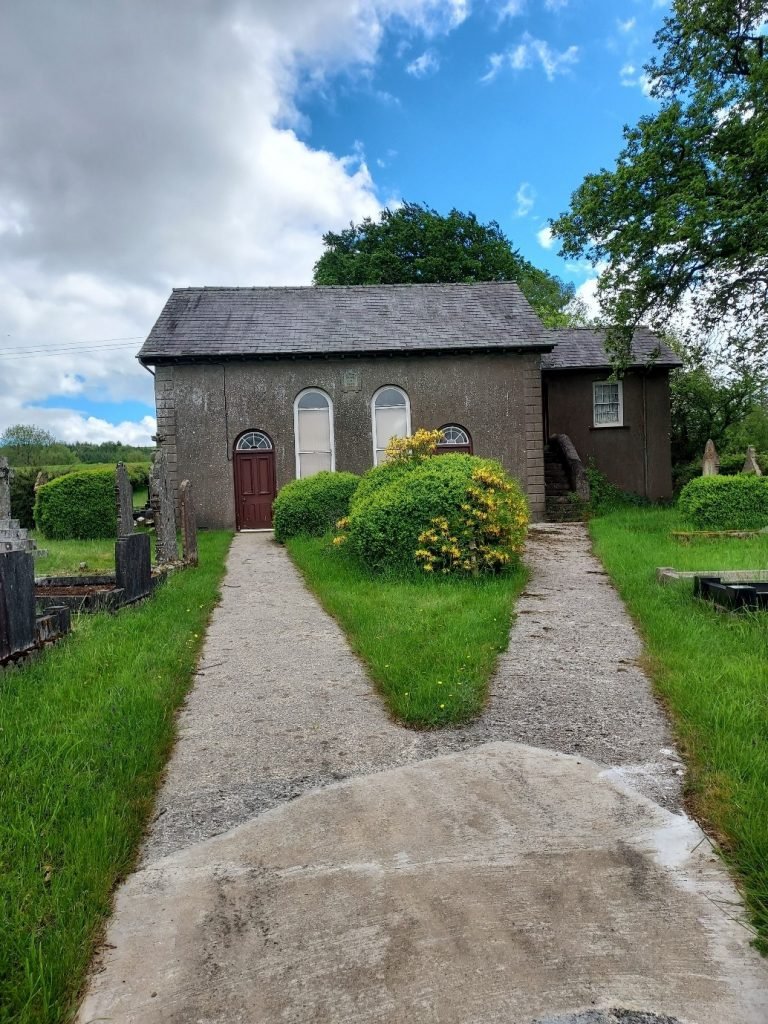
On to Bwlch-y-Rhiw Welsh Independent Chapel (SN8012731976 is the map reference) built in 1871, quite a well kept graveyard around it. Transcribing the graves will be for another time but if you are interested in a bit of research on this place then a good place to start is the National Library of Wales (when we can all get going again). For instance, you could see the accounts for the years 1884-1904.[8] A visit online to Genuki will point you to local knowledge… with many thanks to Mr. David B. James…”The chapel at Bwlchyrhiw was built in 1871. It was erected on land owned by George Jones of Ystrad, Llandovery who granted a 999 year lease at a shilling per annum. The chapel deed states that the building was to be used as a ‘Meeting House for the celebration of DIVINE WORSHIP and in the offering of prayers and supplications to the SUPREME FATHER and GOD of the UNIVERSE’. The chapel was officially opened in June 1872 coinciding with the induction of the Rev Patagonia Humphreys but the first communion service took place in August 1876. Extensive repair and renovations to the chapel were carried out in 1899 – 1900.”[9]
Twny y Fan is the next named hillock on the map, and the homestead we next came upon is Fan Farm. This proved an interesting exercise in searching for records or sources. I searched newspapers, the censuses, chapel records, and maps. ‘FindmyPast’ now has an address search, as does ‘The Genealogist’, with some lateral thinking and comparing records for the surrounding countryside. I have found the Jones family in 1911, Howell aged 34 a farmer and employer, he was born in Trecastle not far from the Roman Camp, Jane his wife was 37 they had been married for 13 years and had 8 children one of whom had died, Jane was born in Caoi (near the Dolaucothi gold mines – back to the Romans), the children were David, Margaret, Howell, Jane, Johnnie and Thomas, all except Thomas were born in Caoi, Johnnie was 3, Thomas was 2 months I can surmise they had moved to the farm sometime between 1908 and 1911. They lived in quite a big house of seven rooms.[10] The Jones family are still there in1939, the register of that year will give dates of birth, and possible married names of any daughters still living with them. The name of the place varies from Fan Farm, Fan Fach, Vanfach, to just Van.
At about 10.5 km into our walk and we next saw Pentwyngarthen, in 1865 they were selling timber from there…
“CARMARTHENSHIRE.
To Timber Merchants, Ship Builders, Contractors and others.
MESSRS. DAVIES and GRIFFITHS, will SELL by AUCTION, on TUESDAY, MARCH 14th, 1865,
at the RED LION INN, LLANGADOCK, at 2 o’ Clock in the afternoon (Subject to such Conditions of Sale as shall be then and there produced), the following valuable OAK and other TIMBER, viz.:
LOT 1. All that valuable OAK and other Timber Trees marked with White Paint, standing and growing on the Farm of PENTWYNGARTHEN, near Llwynwormwood, in the Parish of Mothvey, in the said county.
LOT 2—All that valuable OAK and other Timber Trees marked with Red Paint, standing and growing on the above Farm of Pentwyngarthen.
The above Two Lots are conveniently situated within 4 Miles of the Llangadock Railway Station, having a good Road thereto.
Mr Davies of Ty’n llwyn or Mr. Price, Glasallt, or the Tenant, will shew the respective Lots, and for futher particulars apply to Mr. Thomas Williams, Bridge-Street, Llandilo. Talley.
February 20th, 1865.”[11]
About 1km along on the road we were walking, 120 years ago there was a fierce debate over it…
“Cefn Cerrig Road Again.
The chief business transacted was the discussion as to taking over the new road from the Trustees of the Llwynwormwood Estate.
Mr. John Williams moved that inasmuch as the District Council refused to take over a new road in the parish of Llansadwrn until it had been made at the expense of the ratepayers of the parish, that this Council have nothing to do with the contemplated new road near Cefncerrig, Mothvey until the same had been made at the expense of that parish, and approved by this Council.
Mr. Thomas Williams seconded the motion.
A long debate took place during which Mr. David Davies said that this was a different road to that at Llansadwrn, that being a parish one, whilst this was one which was kept at the expense of the Highway Board, subsequently by the District Council and, if this Authority neglected it, they could apply to the County Council.
Mr. John Williams held that before they could legally take any road over that! it must be dedicated to the public by an Order of the Court of Quarter Sessions.
In this view Judge Bishop, the Clerk and Mr. Evans of Glassalt concurred.
The Chairman said that several roads had been taken over in Breconshire without going to the Quarter Sessions.
Mr. John Davies added that it had been done in many other Counties as well-
Mr. John Williams sharply retorted that that wasn’t proof that they could do things which were illegal.
Judge Bishop thought it would be a very ungracious act on their part, having gone so far, not to take the road over; he was of the opinion that they should do so and go to the Quarter Sessions.
The Chairman stated that when he and Mr. John Williams went up to this place in connection with the first Committee, that then Mr. Williams raised no objections.
Mr. John Williams, however, flatly contradicted this, the Chairman still holding that it was so.
Mr. W. Tudor Lewis moved that the District Council sign the agreement of the solicitors to the Trustees of the Llwynwormwood Estate, to take over the new road, and then go to the quarter sessions.
Mr. John Williams: At whose expense.
Mr. W. T. Lewis (warmly) At the expense of the District Council, of course. At whose do you think?
On the matter being put to the vote, the motion was defeated by 9 votes to 4.”[12]
There are few names to check or add to a family tree in the report.
At about 12 km into our walk and just before we joined the first walk (Llandovery Number 1) route is Rock farm, a check of the Tithe maps shows below[13] a farmstead and fields named Rhoc.

Move on to the 1841 census with some creative searching and there at Rhoc is the Morgan family, David aged 29 born locally, Anne his wife probably, aged 28 not born in the county, and two children, Eleanor aged 4 and David aged 2 both born in Carmarthenshire, Myddfai at an enlightened guess.
Now we were back to the route we had followed the day before on the way to Llwynywormwood and royalty.

[1] Map of the parish of Llandingat in the County of Carmarthen 1840. Davies, David; Morgan, William http://hdl.handle.net/10107/4536394
[2] Census records. Wales. Troedrhiwfelen, Llandovery, Carmarthenshire. 06 June 1841. EVANS, Ann. HO107 PN:1386 BN:8 FN: Page:239. Collection: Census Transcript Search, 1841-1911. www.thegenealogist.co.uk : accessed 29 June 1841.
[3] The Brecon County Times Neath Gazette and General Advertiser for the Counties of Brecon Carmarthen Radnor Monmouth Glamorgan Cardigan Montgomery Hereford (1919). Trecastle Notes and News. 04 September. The Brecon County Times Neath Gazette and General Advertiser for the Counties of Brecon Carmarthen Radnor Monmouth Glamorgan Cardigan Montgomery Hereford P.3b. https://newspapers.library.wales/view/3859738/3859741/18/ : accessed 29 June 2021.
[4] The Cambrian (1824). Carmarthenshire to be sold at Auction 28 February.The Cambrian. P. 2e. https://newspapers.library.wales/view/3325615/3325617/7/ : accessed 29 June 2021.
[5] Census records. Wales. Dagfa, Mydffai, Llandovery, Carmarthenshire. 30 March 1851. JONES, Elizabeth (head). HO107 PN:2470 FN: Page:98 to 99. Collection: Census Transcript Search, 1841-1911. www.thegenealogist.co.uk : accessed 29 June 2021.
[6] Ancient Monuments UK. Hafod Fawr Roman Camp. A Scheduled Monument in Myddfai, Carmarthenshire (Sir Gaerfyrddin). https://ancientmonuments.uk/129885-hafod-fawr-roman-camp-myddfai#.YOxnPjOSk2x : accessed 12 July 2021
[7] Leslie S, Winney B, Hellenthal G, et al. The fine-scale genetic structure of the British population. Nature. 2015;519(7543):309-314. doi:10.1038/nature14230 https://www.ncbi.nlm.nih.gov/pmc/articles/PMC4632200/#SD1 : accessed 15 July 2021.
[8] Papurau’r Parch. W. Rhys Watkin: Cyfrifon Eglwys Y Bedyddwyr Bwlch-y-rhiw, Sir Gaerfyrddin. = Accounts, Bwlchyrhiw (co. Carm.) Baptist Church. Cymraeg/Welsh (1884): Papurau’r Parch. W. Rhys Watkin. Web. https://discover.library.wales : accessed 15 July 2021.
[9] Myddfai: Its Land and Peoples. (1991) James, David B. Publish by the author. P. 2 https://www.genuki.org.uk/big/wal/CMN/Mothvey/Myddfaisnips2#Church : accessed 15 July 2021.
[10] Census records. Wales. Vanfach, Mydffai, Llandovery, Carmarthenshire. 02 April 1911. JONES, Howell (head). RG14PN32912 RG78PN1882 RD597 SD4 ED8 SN6. Collection: 1911 Census For England & Wales. www.findmypast.co.uk : accessed 05 July 2021.
[11] The Welshman (1865). Carmarthenshire. 03 March .The Welshman. P. 4a. https://newspapers.library.wales/view/4352963/4352967/15/pentwyngarthen : accessed 15 July 2021.
[12] The Cambrian (1902). Cefn Carreg Road Again. 28 March . The Cambrian. P. 7d. https://newspapers.library.wales/view/3346251/3346258/96/cefn%20cerrig : accessed 15 July 2021.
[13] Welsh Tithe Maps. Myddfai. Rhoc. https://places.library.wales/browse/51.957/-3.787/17?page=1&alt=&alt=&leaflet-base-layers_66=on : accessed 15 July 2021.