
South Gower Bracelet Bay to Port Eynon. Part 1.
The walk from Bracelet Bay to Port Eynon. About 16 miles along a stretch of the Wales Costal path, close to where I live. A sterling effort from Eva too.
The start point was near Mumbles Lighthouse, in 1849 a Mr. Lewis wrote “The Mumbles Point, an insulated rock at high water, forms the western extremity of Swansea bay; and the trustees of the harbour have erected a lighthouse upon it, which has been productive of the greatest benefit to vessels navigating this coast, and is supported by a small toll payable by each vessel passing within a certain distance. The Mumbles Roads provide excellent shelter, with good anchorage, for ships navigating the Channel, which frequently put in here during the prevalence of westerly gales; to the number, occasionally, of 400 or 500 sail. In these roads, also, are moored the boats employed in the oyster-fishery off the Gower coast; the beds extend from near the Mumbles Point almost to Worm’s Head, at the other extremity of the peninsula of Gower, and in the height of the season about 400 men are engaged in dredging. Immense quantities of the oysters are sent, through factors at Swansea, to London, Liverpool, Bristol, and other markets.”[1]Back to modern times are oysters returning?[2] Stepping back to the history 8 years before Samuel Lewis commented on Mumbles the Lighthouse was under the care of Abraham Ace, the census is our evidence, and this is the record: Abraham Ace aged 60, born in Glamorgan, Light House Keeper, Sarah Ace 68, not born in county, Abraham Ace 21, not born in county a Mariner and Margaret Ace 20, born Scotland.[3] Before moving on, this record might make you think the family consisted of parents and children but a look at the 1851 census shows the Ace’s there still, but with a bit more information: Abraham Ace 32, married, Head of household, born Devon, Light Keeper, Margaret Ace 27 is wife born Scotland also the Light Keeper, Elizabeth Ace 5, Daughter born Redruth, Cornwall a Scholar, John Ace 1, Son, born Oystermouth, Glamorganshire, Abraham Ace 73, Father of Abraham born Penrice, Glamorganshire a Carpenter and Margaret Heath aged 18 a Visitor a Dress Maker.[4] More on this family at an other time maybe, on with the walk.

Mumbles Lighthouse. https://creativecommons.org/licenses/by/2.0/ https://www.flickr.com/photos/s2ublack/
We walked past Fortes Ice Cream parlour, opened in 1936 synonymous with the Macari family. Here is the 1939 register entry: Giuseppe Macari born 14 Feb 1897, a Shop Keeper Ice Cream Maker his wife, Vittoria Macari born 04 Aug 1897 Unpaid Domestic Duties, Elio Macari born 18 Apr 1923, Shop Assistant Dispense Ice Cream, Olimpio Macari born 21 Jul 1925, Not permanently employed, seeking work.[5]
Around the headlands to Rotherslade, in 1859 in deaths notices; On the 1st July, aged 87 years, at Rotherslade, near Swansea, the residence of her son, John Jenkins, Esqr., F.R.A.S., Mrs. Margaret Jenkins.[6]

1840 Tithe map, the Field Number 1025, Field Name Langland field and house, Land Use Arable Landowner George Hughes, Occupier William Phillips, Area 2 Acres 3 Roods, 38 Poles, Tithe Value, 8s. 11d. What on earth would it be worth now?
Price, Francis, & Price, John. (1845). Plan of Oystermouth in the County of Glamorgan. https://places.library.wales : accessed 30 August 2021.
Tithe map, the Field Number 1025, Field Name Langland field and house, Land Use Arable Landowner George Hughes, Occupier William Phillips, Area 2 Acres 3 Roods, 38 Poles, Tithe Value, 8s. 11d.[7] What on earth would it be worth now?
Caswell Bay around the coast, 1881 census around here, had two records connected. The first found a German national, John Schubert Head Married aged 51, a Gardener (domestic servant) born Germany and his wife Sarah Schubert aged 43, Cook (domestic servant) born Bodenham, Herefordshire, England. They lived at Redcliff House[8], next to them their likely employer at Caswell Bay was Caroline A. Morgan aged 38 unmarried, Head of the household, born Llanrhidian, Glamorganshire a Landowner, and Mary Edward 30 unmarried, Servant born Llanrhidian, Glamorganshire.[9]

Brandy Cove is next, what else would it be other than a smuggler’s haunt? “It’s easy to see why aptly named Brandy Cove was such a hit with Gower’s smugglers (particularly local kingpin William Hawkin Arthur and his gang). Surrounded by rocky cliffs that hide it away from prying eyes, there could be few better places on the Peninsula to unload an illicit cargo of tobacco or alcohol.”[10]
William Hawkin Arthur was active in the late 18th century, tenant of Great Highway Farm, Kittle between 1783 and 1794, being the notorious leader of a gang of smugglers.[11] He at least, had a son baptized: Transcribed by me, William Son of William and Grace Arthur, born 10th June 1787 baptized 17th June 1787 at Pennard Church.[12]
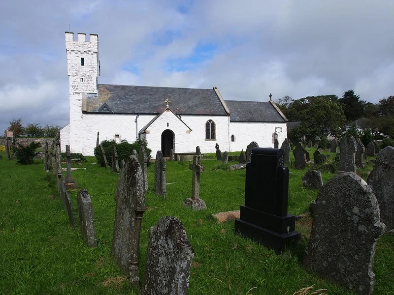
Pennard church. Gareth Lovering
https://creativecommons.org/licenses/by-nd/2.0/legalcode https://www.flickr.com/photos/swansealocalboy/7839547554/
William Hawkin Arthur had his main base at Pwlldu, the next bay around our walk. This is a very atmospheric place, with a few houses remaining. I’ve known or been aware there were pubs there, so searched I did. The National Trust is a good place to start… “It has been suggested that when the quarry was at its peak there were five public houses in the valley. The present Beaufort House and Ship Cottage were the ‘Beaufort Arms’ and the ‘Ship Inn’. The abandoned house may be either ‘The Bull’ or ‘The Star’ with ‘New Inn’ apparently lying some way up the valley on the Swansea side of the river (See 88611). It is not clear how long the five inns were in operation or even if they were contemporary. The Tithe Map of 1846 recorded only the ‘Ship Inn’ and the ‘Beaufort Arms’. In the latter part of the century when the limestone industry had declined the ‘Beaufort Arms’ provided tourist accommodation and it survived as a public house until the 1940’s.”[13] 1901 finds the Beaufort Arms in the stewardship of Jane Jones a Widow aged 57, the Inn keeper, born Pennard, her father David Jenkins a Widower aged 79 a Retired quarryman, born Pennard, William A. Charles Nephew of Jane aged 9, a Scholar born Pennard, Mary J. Beynon a Servant Single aged 22, a Cook, born Pennard, and Louisa Jones Single aged 13 the Housemaid born Ilston. [14] The above mentioned Tithe Map mentions the Jones’ at the Beaufort, with John Jenkins at the other, not named pub. Last note on Pwlldu. Until the beginning of the 20th Century, rights of “cliffage” were awarded to certain privileged farming tenants, who could then strip limestone from the slopes of Pwlldu Head for shipping to Devon, where it was used in making agricultural lime. Blocks were removed along deep gullies, which can still be seen quite clearly, especially from the eastern side of the beach. The stone was then piled up on the low shore and marked with posts. Ships would enter the cove at high tide, locate the posts and beach as closely to them as possible. The consignment was then loaded at low tide. The Devon shipmasters would scuttle their vessels (before the tide was fully out) by opening the sea-cocks. Once the ship was resting on the bottom, the cocks were closed, so that the hull remained full of water when the tide retreated. This water broke the impact of the first blocks as they were hurled aboard. Once laden, the cocks were opened again, the water drained off, and the vessel re-floated when the tide returned. The shingle-banks of Pwlldu are probably entirely the result of the quarrying operations there. All fine rubble was rejected, because it took too long to load. [15]

We followed the coast path climbing up Pwlldu head, looking down on Graves End. Noting where a shipwreck occurred in 1760, the Caesar was the Admiralty tender with 68 pressed men, hands tied or handcuffed over their heads, in her hold. She drove ashore Pwlldu Head, the tethered men drowned.[16] “C.D. Morgan’s 1862 “Wanderings in Gower” relates how a pressgang of twelve sailors under an officer had been thwarted in an attempt to impress John Voss of Nicholaston Hall and his neighbour John Smith before the “Caesar” sailed. Stormy conditions in the Bristol Channel caused the vessel to turn back, though in poor visibility the pilot mistook Pwll Du Head for Mumbles Head – this was thirty years before Mumbles lighthouse was built. The ship was holed on the rocks, now named Caesar’s Hole, and although the ship’s master, mate and some seamen escaped over the bowsprit and clambered up to High Pennard, they apparently neglected to raise the alarm.”[17]
John Voss of Nicholaston Hall was buried St. Nicholas Church there. He died 30 October 1795 and his memorial can still be seen.[18]

Find a Grave, database and images (https://www.findagrave.com/memorial/176426922/john-voss : accessed 04 September 2021), memorial page for John Voss (unknown–30 Oct 1793), Find a Grave Memorial ID 176426922, citing St. Nicholas Churchyard, Nicholaston, Swansea, Wales ; Maintained by Lost Ancestors (contributor 48778889).
On around the path past the promontory fort, High Pennard and Hunt’s farm. But it has to be worth mentioning the caves in this area. Hunt’s Cave, identified by Rutter in Caves of Gower, but now not well identified. Bacon Hole, “The first excavations recorded in Bacon Hole were undertaken by Colonel Wood in 1850 who found remains from the following species: Brown Bear, Cave Bear, Badger, Polecat or Stoat, Fox, Wolf, Hyæna, Reindeer, Red Deer, Roe Deer, Wild Ox, Bison, Pig, Soft-nosed Rhinoceros, Straight-tusked Elephant and Water Vole.”[19] Finally, here, Minchin Hole, “The first important excavation took place circa 1851 when Col. Wood his important finds were the bones of the narrow-nosed rhinoceros and straight-tusked elephant. In 1931 Prof. T. N. George made an excavation near the mouth of this cave. This was followed in 1946 by large scale excavations under the direction of E. J. Mason and J. G. Rutter which continued until 1959. During this period the areas of four hearths of the Romano-British period and the Dark Ages were completely excavated in the upper part of the cave. Since 1972 Dr. A. J. Sutcliffe of the BM (NH) has been making a further detailed study of the Pleistocene deposits. Finds in the cave have included the remains of Reindeer, Bear, Wolf, Hyaena, Bison, Lion, Soft-nosed Rhinoceros, and Straight Tusked Elephant. Evidence of human habitation has been made with finds including over 750 pieces of pottery, spindle whorls, combs, bone spoons, bronze brooches and roman coins.”[20]

Anyway, back to the walk. We were passing Hunt’s farm it’s there on the Tithe map occupied by John Jones, the land owner was Mrs. Margaret Edwards. The 1841 census records this John Jones, as aged 60 (he could have been up to 64, the ages were often rounded down at his census) so he was born somewhere around 1780 and likely born in the area, and another John Jones aged 15 (likewise could have been up to 19) probably born there at Hunt’s farm.[21] Should be enough information to track that family and a history of the farm.
The agricultural influence on this land is unmissable, we walk on around the path to Southgate and the National Trust car park, in 1841 there were two farms, one used by the family of John Edwards, aged about 40, May his wife about 385 and their three children Anne, John and Mary, all locally born, they had two servants Thomas Grove and Mary Hopkin, [22] and one of William Davies, 30 his wife Elizabeth 30 their children John and William, they also had two servants John Rowland and Anne Gibb.[23]

The Tithe map also shows a place called James Grove, [24] John French aged 35 (see above), Farmer, probably his children John French 15, Mary French and Benjamin French 12, there were also two servants Joseph Kift 15 and Elizabeth Lewis 35, all locally born[25]. I wonder how many descendants still live around that part of South Gower.
That takes us to halfway through the walk, seems like a good place to finish this part of the piece. More next week, on to Port Eynon.

[1] Samuel Lewis, ‘Overton – Oystermouth’, in A Topographical Dictionary of Wales (London, 1849), pp. 271-274. British History Online http://www.british-history.ac.uk/topographical-dict/wales/pp271-274 [accessed 30 August 2021].
[2] BBC. Swansea Bay oysters make a return. https://www.bbc.co.uk/news/uk-wales-south-west-wales-29663553
[3] Census records. Wales. Oystermouth, Swansea, Glamorganshire. 06 June 1841. ACE, Abraham. HO107 PN:1424 BN:21 Page: 63. Collection: Census Transcript Search, 1841-1911. www.thegenealogist.co.uk : accessed 30 August 2021.
[4] Census records. Wales. Oystermouth, Swansea. 06 June 1841. ACE, Abraham (head). HO107 PN:2467. Page:117. Collection: Census Transcript Search, 1841-1911. www.thegenealogist.co.uk : accessed 30 August 2021.
[5] 1939 register Wales. Mumbles, Swansea. 29 September 1939. MACARI, Giuseppe. Ref: RG101/7287E/022/34 Letter Code: XIAZ. Collection: 1939 Register. www.findmypast.co.uk ; accessed 30 August 2021.
[6] The Welshman.1859. Deaths. The Welshman. 08 July. P 5f. Collection: Welsh Newspapers. https://newspapers.library.wales/view/4350425/4350430/35/rotherslade : accessed 30 August 2021.
[7] Price, Francis, & Price, John. (1845). Plan of Oystermouth in the County of Glamorgan. https://places.library.wales : accessed 30 August 2021.
[8] Census records. Wales. Bishopston, Glamorganshire. 03 April 1881. SCHUBERT, John. (head). RG11. Piece number 5368. Folio 18. Page 11. Schedule 78. Collection: 1881 England, Wales & Scotland Census. www.findmypast.co.uk : accessed 30 August 2021.
[9] Census records. Wales. Bishopston, Glamorganshire. 03 April 1881. MORGAN, Caroline A. (head). RG11 PN:5368. Page:36 Collection: Census Transcript Search, 1841-1911. www.thegenealogist.co.uk : accessed 30 August 2021.
[10] City and County of Swansea. Piracy and Smuggling. www.visitswanseabay.com/piracy-and-smuggling/
[11] Glamorgan-Gwent Archeological Trust. Gower 062 Southgate. www.ggat.org.uk/cadw/historic landscape/gower/english/Gower 062/
[12] Baptisms (PR) Wales. St. Mary, Pennard, Gower, Glamorganshire. 17 June 1787. ARTHUR, William. P. 13. Collection: National Library of Wales (Aberystwyth) | Pennard Parish (Deanery of West Gower) – Baptisms, marriages (1743-1753), burials, v. 1, 1743-1813 (Pennard-1) www.findmypast.co.uk ; accessed 31 August 2021.
[13] The National Trust UK. Beaufort House and Ship Cottage – Pwll Du, Pennard & Bishopston, Gower. https://heritagerecords.nationaltrust.org.uk/HBSMR/MonRecord.aspx?uid=MNA132018
[14] Census records. Wales. Beaufort Arms, Pwlldu, Pennard, Glamorganshire. 31 March 1901. JONES, Jane (head). RG13. Piece number 5084. Folio 38. Page 8. Schedule 53. Collection: 1901 England, Wales & Scotland Census. www.findmypast.co.uk : accessed 31 August 2021.
[15] The Geological Society. GOWER FIELD GUIDE. Other sites of Geological Interest. https://www.geolsoc.org.uk/Education-and-Careers/Resources/Field-Work-Resources/Gower-Field-Guide/Other-sites-of-Geological-Interest
[16] National CoastWatch- Worms head. Wrecks Information.http://www.nciwormshead.org.uk/miscellany/shipwrecks-introduction/wrecks
[17] Blog Post. Hidden History. 72 The Wreck of the ‘Caesar’, 1760. 22 October 2016. https://gowerhiddenhistory.blogspot.com/2016/10/lives-lost-in-war-thanks-to-mohicans.html : accessed 01 September 2021.
[18] Burials (OPR) Wales. St. Nicholas, Nicholaston, Gower, Swansea. 30 October 1795. VOSS, John. MEMORIAL ID 176426922. https://www.findagrave.com/memorial/176426922/john-voss : accessed 01 September 2021
[19] Ogof.org. Caves of the South Gower Coast. http://www.ogof.org.uk/areas/south-gower-coast-caves.html
[20] Ibid.
[21] Census records. Wales. Hunt’s, Pennard, Swansea. 06 June 1841. JONES, John. HO107 PN:1424 BN:24 Page:128. Collection: Census Transcript Search, 1841-1911. www.thegenealogist.co.uk ; accessed 03 September 2021.
[22] Census records. Wales. Southgate, Pennard, Swansea. 06 June 1841. EDWARDS, John. HO107 PN:1424 BN:24. Page:124. Collection: Census Transcript Search, 1841-1911. www.thegenealogist.co.uk ; accessed 03 September 2021.
[23] Census records. Wales. Southgate, Pennard, Swansea. 06 June 1841. DAVIES, William. HO107 PN:1424 BN:24. Page:124. Collection: Census Transcript Search, 1841-1911. www.thegenealogist.co.uk ; accessed 03 September 2021.
[24] Tithe map https://places.library.wales/browse/51.573/-4.092/16?page=1&alt=&alt=&leaflet-base-layers_70=on
[25] Census records. Wales. Southgate, Pennard, Swansea. 06 June 1841. FRENCH, John. HO107 PN:1424 BN:24. Page:124. Collection: Census Transcript Search, 1841-1911. www.thegenealogist.co.uk ; accessed 03 September 2021.